
136: Banks Peninsula (1)
Two days, one night and one fuel tank later me and my thirsty friend the 4×4 are back in Christchurch for the night…
Yip, it’s a thirsty beast that SUV but it was well worth it 🙂
Had a fab time driving out towards Banks Peninsula via Sumner and Lyttleton.
I saw some White-Faced Heron and Pied Shags on the way to Sumner . Sumner is a little beachfront town. It reminded me of some of the scottish west coast places thought the sea was considerably rougher than you would ever see them in Scotland (I reckon) plus there were plenty of surfers on the beach or the in water, something you won’t find in Scotland either ;-). The beachfront had a nice leng promenade where people went for a stroll or watched the surfers. No gambling halls or entertainment centers nearby which are so common in Scotland so that’s a bonus 🙂
Sumner Pics
(Move your mouse to top of window that opens for slideshow controls and also click on photo for decriptions etc)
There are surfers everywhere on the easy accessible beaches where I have been to sofar. As a matter of fact I am starting to feel rather inadequate whenever I go near the beaches here for not running down from the car park to the beach with a surfboard under the arm, briefly assess the waves for the best spot before enthusiastically jumping into the water and taking on those 4, 5 or so meter high waves ..
From Sumner I drove to Taylors Mistake, a small bay with black sand beach. Went for a little walk up the hills to the east before continuing to Godley Head, a little peninsula that pertrudes into the sea and separates Taylors Mistake from Lyttleton Harbour..
At Godley Head there are several walks from the hill top with great views over the sea and Lyttleton Harbour. I made my way down the hill to the south and almost to the most eastern tip of the peninsula where I could walk through a 100m long tunnel dug into the cliffs that lead to some old Gun Placements. Lyttleton Harbour area was used by the NZ Army for target shooting practices if I read the faded signs correctly… Eitherway, nice view over the sea towards banks Peninsula but by now the sun was setting and I decided to find a place for the night.
I continued along Evens Pass to Lyttleton where I managed to find a room in Pub/Restaurant that offered Accomodation. The Royal Hotel as it’s called had a very British feel to it from the interiour to the bar and beers on offer. They served Steak and Kidney Pie with mashed potatoes and veggies and it went very well with a fab dark ale they had on tap 🙂 I felt at home ;-D
The next morning I wanted to get up to Godley Head again for the sunrise. The first surprise I got was that sunrise South Island means currently 7ish 🙂 Well in Lyttleton anyway and they are in a valley but for Godley Head I thought 5:30/6ish but when I looked out of the window the next morning is was still dark and remained until around 7ish. It was cloudy too so no point going up Godley Head for the sunrise. Instead I slept for another hour or so, had breakfast and then drove around Lyttleton Bay to the other side of the bay. I passed Governours Bay, Teddongton, Diamond Harbour and Purau. A wonderful, scenic route to drive along planty of bays, lovely landscape with plenty of different types of trees and shrubs an some of the houses with their gardens are simply beautiful.
From Purau I could have continued to Akaroa but this was my planned return route so I drove back to Teddington and then via Gebbis Pass to the South-West Route across Banks Peninsula.
Stopped at various places along the southern coast such as Lake Ellesmere, Kaitorete Spit and Birdlings Flat. There and on Lake Forsyth I saw loads of Black Swans there. The first time I have seen them and the black feathers seem strangely odd since Swans ought to be white, right?
From Lake Forsyth I turned inland briefly and went off-track as I wanted to explore some of the southern bays of Banks Peninsula.
The roads turned unsealed but were fairly good dirt roads. There were only a few stretched where a non 4×4 would have struggled but the SUV certainly made it a very easy and fun drive up the moutain and down to the bays.
Initially I tried to drive to Peaki Bay but due to lack of signs I ended up near Te Oka Bay so I drove there instead 😉 I was relatively high up in the mountains (no idea about altitude) and it was getting very misty. I thought “what’s the difference between Mist and Clouds in the Mountains.. probably the same ;-)”..
The longer I drive the poorer got visibility but there were also plenty of clear patches and in many places I could see the mist blowing uphill across the road. Rather fabulous sights..
I was still amidst plenty of mist as oversudden a clear path appeared and I saw a thin stretch of blue in the distance and the shape of a bay. It was a great moment and a definite WOW effect though the view of the bay was still somewhat vague.
Not long though and the sun rid of all the mist and most of the clouds and soon I was overlooking some awesome bays surrounded by the the most intense blue/turquoise waters I have ever seen. The photos I took are not too bad but they still don’t look as amazing as it was in real..
I enjoyed the view for quite a bit, had a brief lunch and then continued down to the Te Oka Bay. At closeup the Bay itself was not very interesting so I continued along the road to the next bay. Views in this area are simply stunning..
I had to drive most of the route back to hit civilisation again and find a place to sleep but there were still a few hours of daylight so after leaving Te Oka Bay I took a detour to Magnet Bay which lies about 15km? west of Te Oka Bay.
The drive there was nice but not as stunning as the road to Te Oka. Nevermind though as i got rewarded in the end with a beautiful pebble beach and surrounding landscape. I shot some pictures there that remind me of the Windows XP Background Picture except much nicer 😉
The land around Magnet Bay are awesome and the bay itself if a nice little pebble bay (difficult to walk on). I saw some Paradise Shelducks and some Spotted Shags there though the Shags were quite far away so difficult to make out the details.
I was thinking this would be a good spot for a sunrise and sunset and did (as one does) check which direction east was for the sunrise .. I didnt have any use for my little compass yet so I gave it a shot and realised that it didn’t make sense at all. Based on the location of the Sun and the time of the day the compass was off by about 70 degrees.
Then it slowly daunted what the place was called where I was.. “Magnet Bay” and the only sense I could make out of the compass reading was that this area was somehow screwing with the compass needle.. Not sure if this really was the case or if I was just simply stupid but if that was indeed then cause then it was quite an amazing thing to experience 🙂
I checked the compass later when I had left the area and sun and compass reading seemed to make much more sense then…
After Magnet Bay I decided that my fuel would last quite a bit longer so I took the long route across the Hills towards Akaroa Harbour via Wainui. It was an excellent decision as I had some awsome views from up there during the sunset.
As the sun set slowly clouds and mist built up again. There were swathes? of mist moving swiftly over fields and sometimes I was entirely surrounded by mist. The light of the sunset played games with the mist and poor me struggled to catch the moments with my camera 😉
Often I just enjoyed the views..
My route took me around the western shore of Akaroa Harbour to the main road. From there I decided to head back to Christchurch because I had to pick up some binoculars that I had ordered.
It was a good day and if that is an indication of what’s to come then it should be a pretty amazing trip here in NZ. I have only done half of the Peninsula and want to go back there to do the main sights of Akaroa but the amazing thing is this Peninsula is TINY and I realise how much there is to see… Lets hope the weather plays along.. 🙂
Map of route (marked in red):
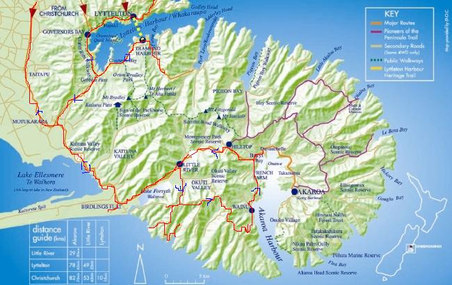
Lyttleton Harbour Map

Tags: New Zealand, RTW 2005/2006, South Island
Leave a Reply