The Nahuel Huapi Traverse
Monday, January 11th, 2010We suffered a bit of a post-Antarctica funk for a few days while in Ushuaia and making the long journey back north (three buses, two pointless border crossings and 50 hours later, and we still hadn’t made it out of Patagonia!). But finally we arrived in Bariloche a week or so ago, ready to resume our Andes hiking tour, this time around the Lakes District in the far north of Patagonia.
 For our first trek in the region, we picked the Nahuel Huapi traverse through the national park of the same name, but in the end there were some variations to the trail due to the third day requiring a guide (and then in fact being closed because of excessive snow/rain anyway), and due to a route-finding mistake on the fifth day that led us down the wrong path and unfortunately caused us to forgo the final part of the traverse. But when it was all said and done, it was a memorable six-day trek with some great moments, but it didn’t quite measure up to the more famous trails around Fitz Roy and Torres del Paine. Some of the best and worst moments are below:
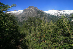
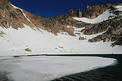
 Lakes: They don’t call it the Lakes District for nothing. Virtually every day of the hike we saw a new, gorgeous lake, and in all cases we looked down on them from above before descending to the shore. We even saw a completely frozen lake for the second time this Argentine summer. The prettiest of all was Laguna Schmoll, beautifully situated, surrounded by jagged peaks, and with part of it covered by a sheet of ice. We had breakfast there on the second morning, completely alone and bathed in sunshine, and it’s moments like those that make it worthwhile to hike for days on end with sore legs and sore feet and sore shoulders and even sorer hips from your crummy sleeping mats.
 Rivers and Streams: For much of Days 3, 4 and 6 we hiked alongside beautiful streams with crystal clear water that flowed beautifully over red rocks and through canyons and produced lovely drinking water. The various methods we used to cross them ranged from rock-hopping to rope-holding to log-crossing to stumbling across rickety wooden bridges, and these were always pretty interesting crossings, especially when we had to traverse a kind of raging waterfall on the way up to Laguna CAB.
The Weather: After a pretty uneventful nine days, weather-wise, in Torres del Paine, this time we got everything imaginable: snow, rain, howling winds and glorious sunshine. The winds on Day 1 and 4 were the strongest we’ve faced in our short camping careers, but luckily our saggy Chinese tent was up to the task and it held up pretty well, especially on Day 4 when Laguna Negra looked more like the Pacific Ocean and the wind howled so much on the way up that I was half-seriously worried about being blown off the cliff. We actually did get blown over a couple of times and had to sit down on the trail just to stay safe. On a more positive note, Days 2 and 3 were stunning and produced most of our good memories (and photos) from the trek.
The Trail: We trudged through snow, clamoured over rocks (sometimes rope-assisted), hiked through forests, slid down snow (fast becoming a favourite pastime), stumbled down scree, squelched through mud and struggled up extremely steep slopes of loose rock and tree roots – yes, this trail had it all.
The Wrong Trail: Blame here is shared between ourselves and the trail markers. Having climbed to a pass above the Laguna Negra on the morning of Day 5, we did not actually pass the signs well to our left that pointed further up the mountain towards Refugio López, and so descended from the pass as you would normally do (following the same route markers – red paint splashes on rocks – that we’d been following for four days). We climbed down into a valley, crossed a river and then went up the other side (with everything still sounding more or less like the LP description), not realising until we arrived at Laguna CAB four hours later that this was the path to, well, Laguna CAB, and not to Refugio López.
Of course, we could have also carried a better map with us, and if I’d exhibited the slightest sense of direction (Wendy, bless her, doesn’t have any to begin with), we would have realised something was wrong a lot earlier. But in the end it all worked out OK, though we never made it to Refugio López. After lunch at the beautiful but rainy lake, we headed back down and camped by ourselves next to a river for the night, enjoying the solitude. The next day we hiked all the way back up to the pass (in record time), back down to Laguna Negra (this time as calm as could be), and then a further 14 kilometres to the park exit by 2pm, which gave us just enough time to scoff down some hot ham and cheese sandwiches before taking the bus back to Bariloche.
—
We still have one more trek to do in the area, but since we’re pretty sore from this one and not quite ready to jump back on the trail again, we’re heading across the border once more to Chile tomorrow to check out the misty and mysterious islands of Chiloé, before coming back to Bariloche at the end of the week to tackle the fabulously named Mt. Tronador (Mt. Thunderer).
