
Days 247-252: Annapurna Circuit Trek, part 1
We heard that if you trip in the Himalayas and accidently snap a picture, it’ll be great. So that’s why there are so many pictures for this 17-day hike around the Annapurna range in Nepal (Marcus tripped a lot). This is part 1 of 3. [Yeah, we left out a week in Kathmandu. We’ll cover it later.]
The Annapurna Circuit trek is a bit more than 200km for the route we took and circumnavigates spectacular mountains. Some of these mountains are higher than 8000m (26,250′). We opted to not take a porter or guide; a decision we seriously questioned at times. We rented some cold weather gear in Kathmandu that was more industrial strength than high-tech; light weight it was not. So our bags were a bit heavier than we normally carry. No problem though; our bodies would toughen up and adapt to the load. Right? We bought a book that describes the route in detail and a pocket map to keep us from getting too lost.
Day 0: Kathmandu to Besisahar (760m or 2,493ft)
The traditional start of the route is the town of Besisahar which lies about 150km outside of Kathmandu. We travelled to Besisahar via bus and minivan and decided to eat “dal baht” for dinner. This meal, the national dish of rice, lentils, and curried veggies, was to be our staple meal along the trail.
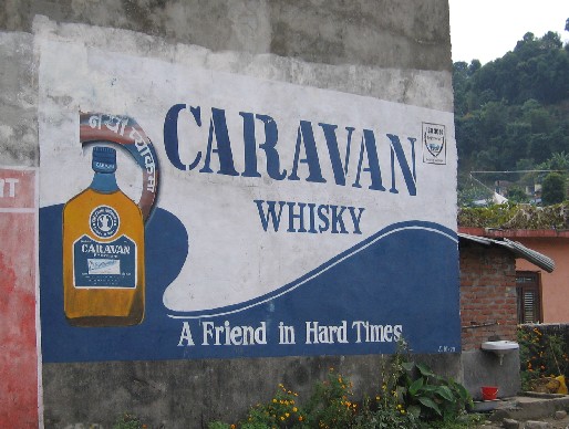
Perhaps a sign of things to come, a liquor ad on the way out of Besisahar forecast tough times ahead for hearty trekkers.
Day 1: Besisahar to Bahundanda (1,312m or 4,300ft)
Before we go any further Kelly needs to explain something about her, ah, lack of fashion. We were told (at a lecture we attended and by our guidebook) that “sexism is alive and well in the hills.” Essentially a female in a skirt is accepted, in pants she is not, and in shorts she is assumed to be a prostitute. So, Kelly bought a skirt but accidently left her blue shirt that coordinates with it in Kathmandu. A fashion show this was not.
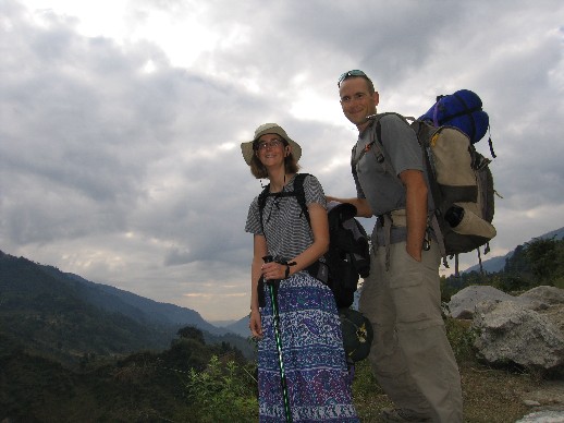
Our start of the hike photo: clean clothes, clean shaven, clean bodies, and no seriously sore body parts.
We became Canadian on this day. Seriously. For the first time on this trip we answered “where are you from?” with Canada. This was a financial decision because three groups of Maoist rebels inhabit the trekking route. The groups extract a “donation” from trekkers, and for some reason Americans are charged about four times the usual rate (Belgians also get hit because they sell arms to the Royal Nepalese Army). So how’s about we go out in boat, eh? A big thanks to all Canadians here. We were incredibly well received and the real Canadians were kind enough not to give us away.
We took the wrong trail (read: more difficult) right off the bat. Met a gal at lunch who took the right trail, but managed to sprain her ankle about 3 hours into her trip. We gave her some ibuprofen and didn’t expect to see her again.
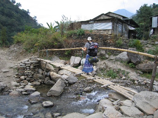
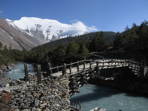
One of the many bridges we crossed. Not the most trustworthy construction here. So Marcus let Kelly go first to test it out.
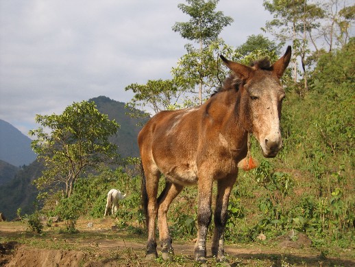
The donkeys started out looking like what you would consider normal.
Pretty much everything gets hairier the higher we went, including us. No razors were brought on this hike to save weight. Wouldn’t have done much good to bring the electric razor since there wasn’t much power for the first half of the trip.
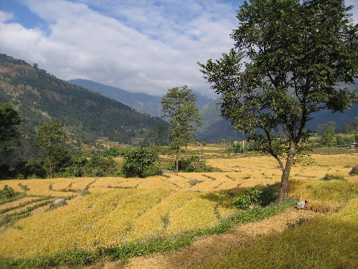
Typical view early on the hike. Lots of rice fields, banana trees, and bamboo. Much more lush than we were expecting for the Himalayas.
That evening we arrived in the town of Bahundanda and pretty much had the place to ourselves. The lodge owners begged us to stay because of so few tourists and it’s the high season. They offered us rooms that were either free, or effectively free, if we ate at their restaurants. This is when we learned that the price of the room was irrelevant compared to the price of food. All of the restaurants in each town had exactly the same menu for ridiculous prices. But they are all “approved” by the local Tourism Management Committee. We later found out this is just a bunch of villagers that agree to charge tourists a lot for food.
We got our first – and only – test of being Canadian when someone asked us what exchange rate we got. Yikes! After that, we decided we had to know all sorts of good Canadian stuff. Who’s the prime minister? What’s the capitol? How does “O, Canada!” go? Are the Maple Leafs going all the way to the World Series this year? (just kidding). We also got what was to be the first of many cold showers.
Day 2: Bahundanda to Chamje (1,430m or 4,690ft)
Pretty sore to start the day and getting more sore. Dal baht is getting pretty pricey (over $2 now for rice, lentils, and potatoes grown locally).
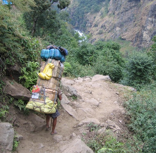
Seeing lots of porters carrying crazy amounts of weight up these mountains. This guy’s load was bigger than he was!
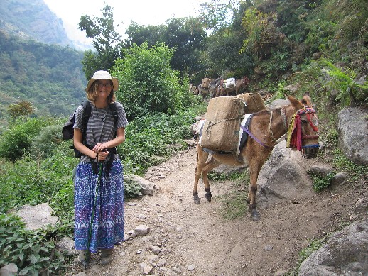
We thought the price of the food could be justified if it was coming up the mountains on the back of some overburdened porter. Well the truth was much less romantic. There are constant trains of donkeys schlepping goods up and down the trail getting beaten with a stick way too often. We began to realize the hills are not a terribly animal-friendly place.
Kel with one of the real workhorses of the hills.
At a rest stop in the town of Jagat, we found a water spout that had been painted by the locals. One side read “Welcome to all our international guests” while the other read “Long Live the Peoples War!” and had a cartoon of the Nepali king decapitated. Definitely getting into Maoist territory.
The hills had plenty of critters to keep Kelly emptying out her shoes in the morning.
Our hotel’s kitchen wasn’t the most sanitary place. The cook kept farmer Johning her nose in the kitchen, and a snot-nosed kid was eating sugar out of the communal sugar bowl with a spoon. It was not surprising when Kelly caught a cold the next day that would dog her the rest of the hike.
Day 3: Chamje to Bagarchap (2,160m or 7,085ft)
Lots of uphill today – or at least that’s what it felt like. We had a long walk through a scenic river gorge. Started seeing porters wearing Cal hats in the wrong colors (red & black, white & beige?). Let’s give a quick “Go Bears!” for their victory over Stanford.
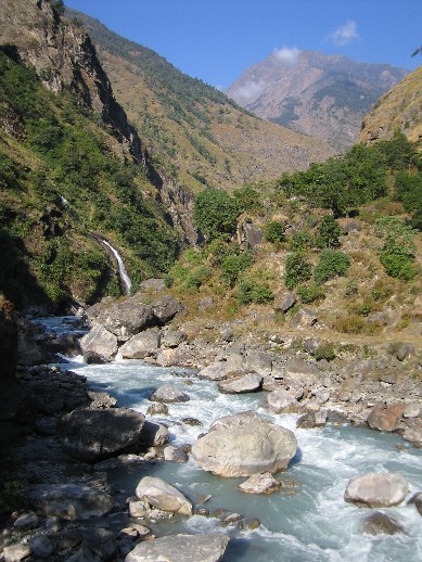
Nice river valley.
Had our first bad meal, and only bad dal baht of the hike. Dal baht has achieved new heights costing almost $3. It is the second the most expensive thing on the menu; only a few rupees behind a chicken pizza which requires the cook to go find and kill a chicken! It is still just rice and lentils and potatoes. A small pot of tea is now $2 – a tea bag and hot water – but a bottle of Coke was only $0.75. Which weighs more to carry up a mountain: a tea bag or a bottle of coke? Insanity.
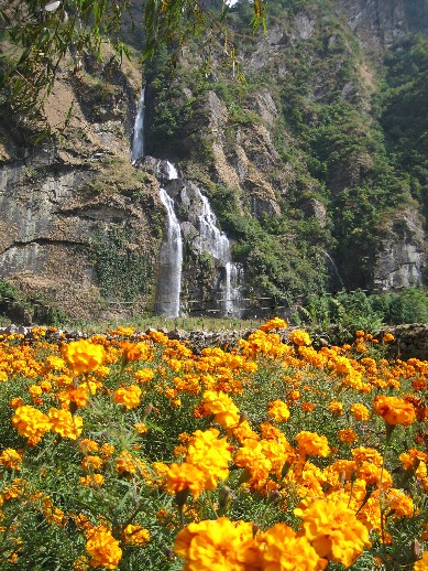
Lots of gorgeous waterfalls along the hike.
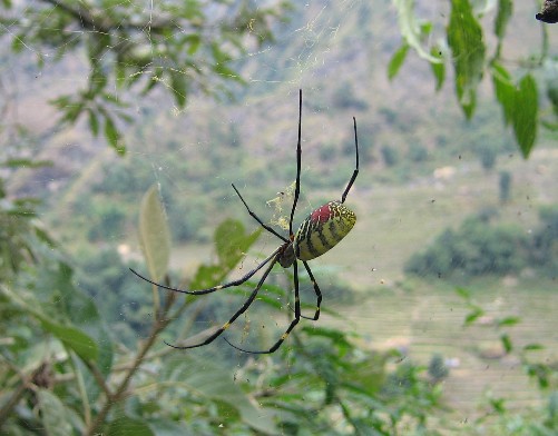
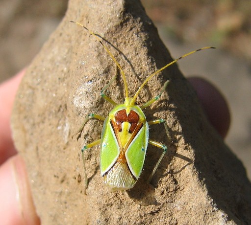
Another cool critter. Check out those blue knees. Not many bugs beyond this point though.
Definitely getting colder. The sun sets behind the mountains about 3pm and the temperature drops like a rock. Kel braves an icey “solar shower” to wash her hair. This would be the last hair washing for over a week.
Day 4: Bagarchap to Chame (2,670m or 8,760ft)
Where did all these people come from? The trail and towns were pretty much empty for the first three days. Now we had tour groups of 20+ Germans, French, and Israelis staying in the same town. Not to mention all the adventure racers that whizzed by us going the other direction. We heard later that they did the full Annapurna Circuit and Sanctuary – going the tough way – in only 7 days. Man! they were tough.
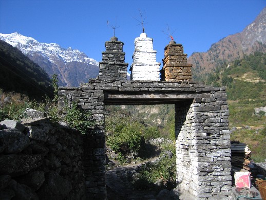
Most of the towns had these gates going into and out of town. The inside has prayer wheels for people to spin.
The weather cleared up on day 4 and would stay beautiful for the rest of the hike. Spectacular!
We came to a fork in the road: one way went up and took longer and one way went down and took less time. We opted for the low trail and just about got around the bend before people yelled at us to come back. The upper path led to a road being constructed in the hill side, and the road crew was blasting and dumping huge boulders down onto the lower path. All of the villages on the lower path had been evacuated for safety. We did find a sign explaining what was going on, but it was located on the upper path only after you started on it. First and only time we regretted not having a guide.
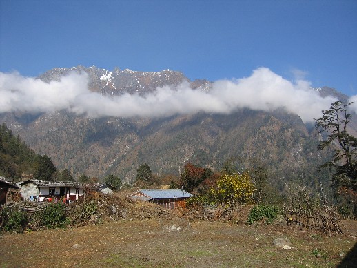
Village in the clouds.
As we got into the town of Chame we had our first check-point. There were three of them: one of them was the Annapurna Conservation Area folks checking to see that we paid our $27 each to enter the park, the second was the army to make sure we weren’t Maoists, and third was the police for who-knows what reason. This was the first place we saw signs of the military on the hike, and it meant that we had passed the first Maoist group without having to make a donation.
Chame was cold. It was the first time we can remember being able to see our breath inside of a hotel room by candle light. Yeah, there had been power. But the power went out shortly after Marcus electrocuted himself trying to wire an outlet to recharge a camera battery. We’re sure it was coincidental. No, the battery did not get charged; that’s why we brought three.
Day 5: Chame to Upper Pisang (3,300m or 10,800ft)
We left the lush valleys for evergreen forests and huge rock walls. The houses have changed from wood to stone Tibetan-style, and there is a lot more Buddhist religious objects.
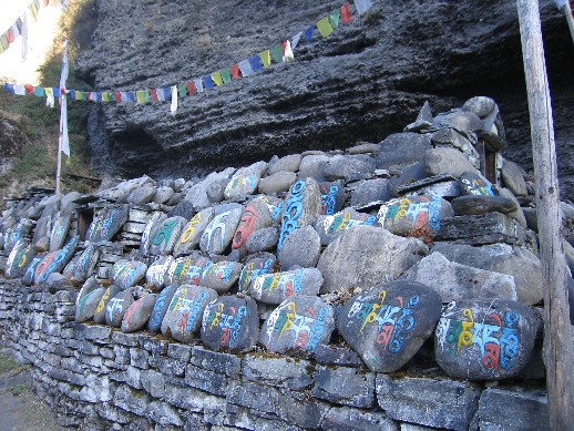
Mani wall.
The scenery is starting to look a lot more alpine.
The town of Upper Pisang was great! It commanded a fantastic view of the river valley and the big rock wall. Lots of livestock roamed free around town. Marcus was nearly trampled by a pair of bulls that decided they didn’t like each other after he walked between them.
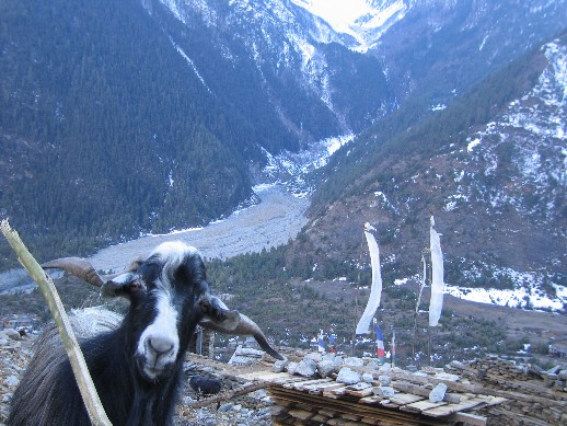
One of the locals checking out what Marcus is up to. No, you can’t eat my polar fleece!
We had what was the finest hot bucket shower of all time until the wind gusted through the wood planks in the outhouse. After many a cold shower, it was still luxurious. Marcus got food poisoning for the second time in Nepal during the night. At least he got to see the gorgeous night sky during his frequent trips to the outhouse.
Tags: Nepal
December 6th, 2005 at 7:07 am
Glad for the disclaimer. I don’t think Kelly would make the ’10 Best Dressed’ list….
The goat was cute though…
December 6th, 2005 at 5:33 pm
Holy smokes! Was that spider as big in person as it looks in the picture? I’m with Kelly regard the morning shoe check…whoa!
Great post.
December 7th, 2005 at 7:32 am
Suzi – Are you saying that a goat is more cute than your first born/my sweet wife?? 😉 I tried to get the goat to eat Kel’s skirt, but he didn’t like synthetics.
Jon – I swear that every country we’ve been to has had spiders the size of full grown dogs. Kelly tries to ignore them, but I make sure to point them out.
December 7th, 2005 at 1:44 pm
wow…soo beautiful…glad to see you guys are well….all is well here 🙂
December 8th, 2005 at 7:10 pm
Sweet hike! Glad you guys are havin’ fun. As an aside… Personally, I have always found single malt scotch to be the best friend in hard times. You might wanna pass that along to the locals.
Keep those cards and letters comin’ Uncle FatBoy!