
Alpamayo Trek
18 hours or so in Lima – which were fairly painful – central Lima is fairly manky, and being there at night doesn’t help. It doesn’t have a central bus station either, so trying to find a bus out of there was slightly difficult. We thought we’d found a bus to Huaraz at 6.30am the following morning, but when we checked in our luggage we found we were the only people on it, so it had been cancelled. We then spent a stressful hour or so trying to find another company, that wasn’t full and didn’t cost a fortune (all the expensive buses were full, all the cheap ones empty – bizzare). Unfortunately all the companies offices are in a really horrible bit of town, which didn’t endear us to Lima either. We do have to pass through again to pick up our flight to Mexico and, hopefully, daylight will improve matters…we’ll see!
We finally fnd a bus to Huaraz and 8 hours later pull in.
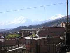
Our first impressions of Huaraz weren’t great either – this place has a half built feeling about it – it has a history of being destryed by earthquakes so probably not that surprising. It is ringed by snowcapped mountains though, which come as a bit of a shock.
Huaraz is the hub for treks in the Cordillera Blanca, and after much deliberation, we decide to head out on the Alpamayo Base Camp Trek, spend a night in a little village called Pomabamba – restocking on food, makes for lighter packs – and head back to our starting point along the Santa Cruz Trek, which is probably the most popular trek in the region. (see map here)
Day 1: Cashapampa to Hualcayan
Two collectivos, white minibuses that are the backbone to life in Peru – basically a shared taxi, later we arrive in Cashapampa for the start of our high altitude trek through the Cordillera Blanca. Cashapampa is basically the start for the Santa Cruz trek, and where we were intending to walk out of 12 to 13 days later (more of that story to follow!). Without really thinking we paid S./5 (just under 1 gbp) each to register – we were registering for the Santa Cruz trek though, nevermind, we could prove we paid on walking out.
Instead of heading up the SC trail we set off on the road. The notes we had, from the LP trekking guide (which we found to be quite inaccurate along the way and got very frustrated with it – how can you judge when you are 400m above a river? Surely it is better to tell you at what height you should be at rather than a best guess estimate. The map they recommend shows clearly you are only about 150m above it…ridiculous – rant over, sorry!) suggest you meet a sandy trail, which we did – but there are a number of sandy trails in and around Cashapampa! The joys of being in a town and only with a 1:100,000 map – oh for a good OS!! Having said that, this is the best map we’ve had on our travels so far. Anyway, we found the road leading out of town from the path we took and headed down. Another gripe with the book, it doesn’t mention any descent (only 250m of ascent), we certainly had some descent the first day!
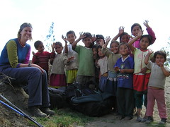
We passed through the village of Huancarhuas and recieved lots of interest from the local kids – the third group we met put up the call of gringo (slowly getting used to being called gringo) and came running to meet us. After establishing we were on the right path we sucumbed to the “caramelo mister” cry – a standard cry from any child you meet on trek.
From the village we skirted round the foothills of the Andes, mainly going downhill, before crossing a bridge over a steam and a steep climb up to the village of Hualcayan. Boy did our bags feel heavy. It took longer than expected to get there, but once in the village we met with a very helpful lady who sold us a bottle of Inca Kola (the soft drink to be seen with in Peru) and who showed us the way to the campsite, basically a flat bit of grass next to the football pitch.
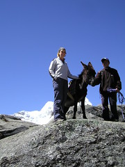
We received a lot of interest from the local kids here too – and we are slowing getting used to being called gringos! We noticed the man living next to the campsite had a donkey, and we had the controversial idea of hiring a man and his burro for the day to help with a 1,400m climb from 3150m up to 4600m and the next days campsite. So we approached him, and before we knew it we had a deal.
Day 2: Hualcayan Pampa to Laguna Cullicocha
Early start – David the Donkey and Erasmo (his driver) turned up at 7am to be loaded up with our big backpacks. He set a fast pace – which I couldn’t keep up with – but he certainly made the 1450m climb up to Laguna Cullicocha much easier than it would’ve been with the large rucksacks on our bags.
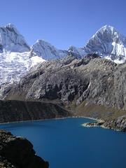
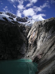
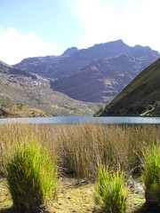
After 5 and a half hours of walking (with a couple of substantial breaks) we arrive at Laguna Cullicocha – an impressive emerald green lake sitting below snow capped mountains. A strange place, beautiful setting spoilt by an irrigation company and concrete all around the base of the lake. Although we were welcome of the buildings an hour or so later as the wind was whipping through us sitting by the lake and they gave us some shelter!
Day 3: Laguna Cullicocha to Jancarurish
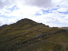
Not such an early start today as we let the tent defrost in the sun before setting off. The first hour or so is a climb up to 4860m and the Paso Osoruri – our highest pass on the trek. Unfortunately it is a bit of a let down and there are no views at the top so it is downwards for us. After walking over an un-named pass (4740m) and have the awful view of seeing our path descend 600m followed by a steep ascent up to Paso Vientunan (4770m), very disheartening.
The climb up to Paso Vientunan was hard work and we were really feeling the weight of our big bags at this point, where is David when you want him?! From here we dropped again and then siddled above the valley and past Ruina Pampa to our campsite for the night – Jancarurish. On the way down we bumped into a group of c.23 donkies making their way up followed by 13 Americans, they weren’t enjoying the climb up (but then again we probably looked like they did at the otherside of the pass struggling up!)
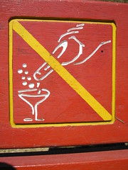
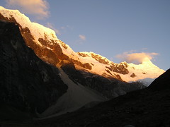
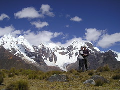
Jancarurish is a beautiful place to camp, with stunning views of Alpamayo, although we were slightly confussed by the no champagne signs…as if you’d carry champagne up with you, and if you can be bothered, why can’t you drink it?!
Day 4: Day trip to Alpamayo base camp and up towards Nevado Santa Cruz Chico
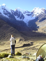
Leave our tent where it is, with the big bags stored safely inside and a local (who was with a Swedish couple) protecting our food and tent from the cows and pigs wandering around and head on up to Laguna Jancarcurish and the Alpamayo base camp.
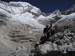
Laguna Jancarcurish is another beautiful lake set below snow capped mountains and the climb didn’t take as long as expected. Alpamayo base camp was a bit of a let down – no view of Alpamayo!!
It was a hard climb up the moraine wall towards Nevado Santa Cruz Chico and we stopped short of the trip described in our book by about 100m and sat for lunch at the bottom lake, rather than the top, as I wasn’t enjoying the boulder scrambling and the scree marbles underfoot.
It was cold and windy, so we didn’t hang around for long, and the descent wasn’t as bad as I was expecting, although we avoided the worst of the scree marbles by making our own path down.
Day 5: Jancarcurish to Alta Huillca
Another steep climb first thing in the morning from 4250m to the Caracara pass at 4830m. Hard work, but feeling better than we did on day 3. It was incredibly windy at the top and the “views southeast across to Nevado Alpmayo are superb” (as per LP book) didn’t materialise. What views? All you could see was a close hunk of mountain blocking the view…
Another drop, followed by a climb, but not a steep as the others had been, more a nice traverse, up to Paso Mesapampa (4460m). From here we were half intending to walk to Laguna Safuna and we didn’t fancy having to back track the next day, neither did we fancy heading down to Huillca itself as we try to avoid camping in villages/towns when we can – also the trekking notes say that you can encounter begging from the locals and didn’t really want to have to deal with that. Instead we picked a flatish-spot near a stream and stayed put just down from the Mesapampa pass (4275m).
Day 6: Alta Huillca to Alta Janca Pampa
Down to Huillca (4000m), an odd place – flat, slightly boggy, area. Don’t encounter any begging (apart from the odd “caramelo, mister?” from a couple of kids). According to the notes, there was supposed to be an obvious path up to the Paso Yanacon (4610m) – but it took us a very long time to find it. When we did it was torturous – straight up with hardly any zigzgas – really hard work – despite the lighter packs!
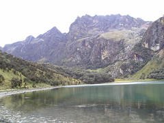
From the pass it was a lovely walk down to Laguna Sactaycocha (4050m), a stunning lake set inamongst quenna trees on one side, with a high walls (of some type of rock, but not being a geologist can only say that they were grey!) on the other side.
We had half thought we’d camp here as we were both suffering from the climb earlier in the day, but as it was cold and only 2.30pm we decided to head down towards Janca Pampa, another flat, boggy area with scatterings of houses. It was quite fun trying to find the main path from the lake (the lake was just off the path) and we had to scramble around for a while along cow trails and pushing through scrub, but we found it and about and hour and a half later hit a flat spot, by a stream and decided that it would make a great camp spot rather than head to Janca Pampa itself.
Day 7: Alta Janca Pampa to Pomabamba
Awoke to a very frozen tent – which is quite fun to pack up – the sun wasn’t going to hit it soon enough for us to hang around, instead we head down to Janca Pampa (only about half an hour) and spend about 45mins drying it out there. From there we wander (and squelch) along boggy ground towards Pishgopampa and Jancapampa villages. It is here that we meet our most unfriendliest children, who start throwing stones at me when we say we don’t have any caramelos.
The plodge down to Pomabamba takes us through little villages, some people seem pleased to see us, most seem grumpy and don’t really respond to our “hola, beunos dias”. it also seems to take for ever, we always find walking out hard work.
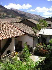
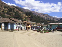
Pomabamba is a pleasant enough town, and we find a hostal easily enough, our cheapest room so far – S./20 for a double room (c. gbp 3.25), but no shower, you have to go to the thermales, I suspect most places are like that in town. The thermales are also a welcome relief to aching muscles and dirty people, a hot shower! Pomabamba seems to be being dug up at the moment and a new water supply put in.
We manage to polish off a whole roast chicken and chips for dinner – how greedy did we feel? It was delicious though and a lovely change from pasta/rice and soup, chorizo & onion sauce – our staple trek dinner.
Day 8: Rest day in Pomabamba
A very lazy day, we are in need of it. Buy more supplies for our 5 day walk back to Cashapampa, spend some time on the internet and avoid the chicken head soup for lunch – doesn’t really appeal!
Day 9: Huanchabamba to Laguna Huecrucocha
Up early to try and get the red collectivo to Huanchapampa which apparently goes at 6am, but we couldn’t find it! We were half disappointed that we weren’t spending another day in Pomabamba as Sunday was market day, and the number of people setting up stalls, arriving with goods on the back of donkies was amazing at that time. Peru time is a bit odd though, as the sun rises around 6am and sets around 6.30pm. Certainly a morning-type country!
In establishing that the collectivo had already gone, a helpful man arranges a private transfer for us (which turns into a collectivo as we head off and more and more people jump in!).
We are off and walking from Huanchabamba by 7.15am up towards Ruinas Yaino. It is a hard two and a half hours walk up (from 3500m to 4075m) and on arrival at the ruinas establish that they are going to charge us S./20 each, which is expensive for some stones on the top of a mountain, which would take about 30mins to walk round, so we don’t visit. Instead we head towards the village of Quisuar (up and over a couple of passes) and up to the lake.
The locals here are certainly friendlier than those at Janca Pampa – no stones thrown at us in any case!!
It starts to rain as we climb up the last 300m to the lake shore (4000m) and we are both really struggling today – every step is hard work.
The lake is a pretty and the rain clears, although the clouds clear.
Day 10: Laguna Huecrucocha to Pomabamba
We both awake not feeling too well and the weather isn’t great either, lots of clouds so we can’t see the pass and it trying to spit every now and again. We head off, but I really struggle with any up – having to stop every 10m or so to breathe deeply and concentrate on not being sick. We stop at the top of the lake and decide our options:
- Continue up over the Alto de Pucuraja (4640m) pass
- Stay put (in the cold)
- Walk out – along the route that doesn’t look like it has any up – all down.
We decide on option 3, if the weather had been better we may have stayed put – there was no way I could continue with the up. We think we were probably suffering from exhaustion/alttitude – despite having been higher over the last week.
The walk out to the village of Lucma (3300m) is really hard work – we don’t actually do any real down until about 30 mins out of town – just lots of up and down. It also takes longer than expected and we don’t get there until about 4pm. We met our friendliest children yet as we walk past a school – they all come out and shake our hands as we walk past – takes a good couple of minutes to shake everyones hand!
We hire another “private” collectivo back to Pomabamba and have the debate about whether or not to catch the 7pm bus back to Huaraz, but I don’t think I can hold on to my stomach over the bouncey, twisty roads for 8 hours or so, so we decide to stay the night.
Day 11 – 13: Pomabamba to Huaraz
It turns out that Nick is the one who can’t hold onto his stomach overnight and we have to stay put for another night as he isn’t well enough to travel the next day. We book our bus tickets for the following day (day 12) only to find, when we go to the bus station, that there are some sort of strike on and we can’t travel…another night in Pomabamba for us then.
We thought we’d “done” Pomabamba the first time we were there and neither of us were too happy about having to spend another night there, but I’m sure there are worse towns to be stuck in! We also can’t complain too much, as it is the first time we’ve really come unstuck in near 9 months of travel.
Day 13 at mid-day sees our bus pull out of Pomabamba towards Huaraz – third time lucky!
The journey is stunning but as we get to Yungay (about 7 hours in) we start to see the remains of the strike. An amazing number of stones / trees / burning tyres on the road. It is more an obstacle course than a road. It gets slightly worrying at one point when we stop and it looks, for a while, that we aren’t going to get through – people are throwing stones at passing cars…the driver and a group of passengers head off to talk to the protestors to see if we can get through – they come back and see set off again. We are both slightly nervous at this point. However, we finally pull into Huaraz at 10pm – a welcome relief and quite an adventure. It sounds like we’ve been quite luck though, as the strikes / protests have so far left 3 people dead.
It appears that the strikes are by teachers and other professionals demonstrating against the government and the distribution of wealth in Peru – an interesting article about them all can be found here.
Tags: Peru, Travel, Trek
Leave a Reply