Hiking in Bariloche
April 30th, 200624-2-06
Everything they say about Bariloche, in the northern part of Patagonia (lakes district) is true – awesome mountains, sparkling blue lakes, good pubs and restaurants (delicious trout!) and the best chocolate in Argentina. It is also a bit touristy…so we headed off into the mountains for a 3 day hike.
The first day we made our way up to Jacob lake, passing through periods of sunshine, rain, sleet/hail and snow…all in about 6 hours! The scenery was magnificent and we only saw a couple of people the whole day. We followed one of the clearest and prettiest rivers I have ever seen up the valley, steadily climbing into the higher mountains until the path took an ubrupt turn…up. This was the first time, but not the last, we realised that hiking trails here don’t contain many (if any) switchbacks, I guess the idea is if the terrain gets steep you might as well take the quickest way up?! Anyway, it was all good, we pounded that 400m slope thinking most of the rest of the way would be flatter or down (not looking too closely at the topo map yet!) and so congratulating myself on feeling pretty good with the big pack and steep ground.


(Click the images for the bigger pictures).
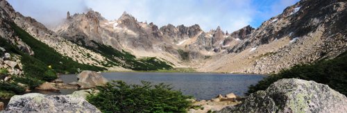
Pitched tent at Jacob lake, a pretty blue lake surrounded by craggy mountains and glacial carved valleys. About an hour after we arrived it started to snow properly with nice flakes. Pitching our tent with the best view of the lake (also the most exposed site) didn’t turn out to be such a good idea when the wind started blowing at over 50kms per hour. Oh well, we weighted it down with our gear and popped over to the cosy permanently lived-in refugio for a couple beers to warm us up. Cooking dinner, keeping warm and sleeping was a bit of a challenge the first night as the wind got so strong that the tent was lifting beneath my legs. It did teach us some valuable lessons on tent site and direction of placement though.


Next day was much the same weather with particularly gusty winds and intermittent snow/sleet with glimpses of sunshine. Were a bit confused about the route thinking we would follow the valley up but more careful inspection of the map proved otherwise and it finally started to dawn that that big scree slope on the left was the way…. Again, no switchbacks, straight up 500m elevation and unbelievably steep.


The view from the top of the ridge was a ripper and after downing some energy-giving chocolate at the top we descended into a beatiful forested valley for lunch. By this time I wasn’t quite as naive about this trail and so wasn’t totally surprised to see the track leading out of the valley going up an even steeper and higher scree slope (700m elevation gain). I was also starting to realise why the trail was called the Frey-Jacob trail, and not the Jacob-Frey. We hadn’t seen or met anyone going the same way as us (and wouldn’t for the rest of the trip) and quite a lot of people coming the other way, who, when we saw them in the valley after they’d made their way down that slope were saying to us stuff like – wow, you guys are going to find that pretty tough, I wouldn’t want to climb up that etc etc. Yeah… not a good sign.
Anyway, we made it and it only took 2 hours to get up (the same time as 2 girls told us they took to get down it!) … although the scree turned into quite sandy stuff about halfway up so it was a pretty frustrating 2 steps up, 1 step back. On the other hand the view from the top was incredible and the huge sharp rock spires that crowned that 2nd ridge were amazing (I really need to find some more adjectives!).


Descending down past another picturesque glacial lake to the valley below we finally made it to Frey Lake, located in one of the most spectacular settings I’ve seen, surrounded by the rock spires (also a big rock-climbing area) and a great view down the valley. We treated ourselves to another few beers at the refugio (I LOVE these things), bought a bottle of wine for dinner and set up camp in a much more sheltered position (but just as pretty). All things said a much more comfortable night!


The hike down to Cerro Catedral village (in winter one of the biggest Argie ski destinations) was a very easy 3 hours, but a little disappointing compared to the views on the other parts of the hike. Although there were some nice lake views a fire had been through a couple of years ago and like Canada, it takes ages for the forest to recover.
The hike completed, we holed up in deserted Catedral for the day and night before reluctently heading back to work.