BootsnAll Travel Network


Archive for October, 2008

« Home

Homelessness

Friday, October 31st, 2008

Today was the last day in our house before the renter moves in.  We’re very excited that someone will be living there (and paying the bills) while we’re gone, but it was still a little bittersweet to see it completely empty. 

It was also a little scary to see our bags with the only things we’ll have for the next year.  They looked so small sitting in the big empty house!

blog-luggage.JPG

We’ve been spending the last week packing, making trips to storage, and saying goodbye to family and friends.  We’ve also been doing those last time visits to our favorite food places – I’m really going to miss In-N-Out and Wahoo’s fish tacos! 

It’s been exhausting, but it’s finally time.  I still can’t believe we’re leaving tomorrow.  Happy Halloween to everyone! 
Z is for Zion

Saturday, October 18th, 2008

Our last stop in Utah was Zion NP.  It’s very different from the ABC (Arches, Bryce, Canyonlands), but each park is unique so it’s hard to pick a favorite.  Zion has sheer cliffs and more trees, plants, and wildlife.  We saw a crane, many deer, and chipmunks seem to come out of the rock itself as soon as they hear any type of food wrapper crinkle.

Springdale is the closest town just outside the park and it’s also quite different from the other parks.  It’s filled with espresso bars, cafes, art galleries, and spas.  The other key difference is that no cars are allowed on the scenic drive inside the park.  Instead, there is a shuttle bus which makes stops at specific points in the part.  Although it was controversial, it drastically reduced the traffic in the park which had become overwhelming in the 90s.  We found it to be very efficient and never had to wait more than a few minutes for the next bus.  The combination of amenities in Springdale and the shuttle give the park a “touristy” feel though, a bit more like Disneyland than a typical NP.

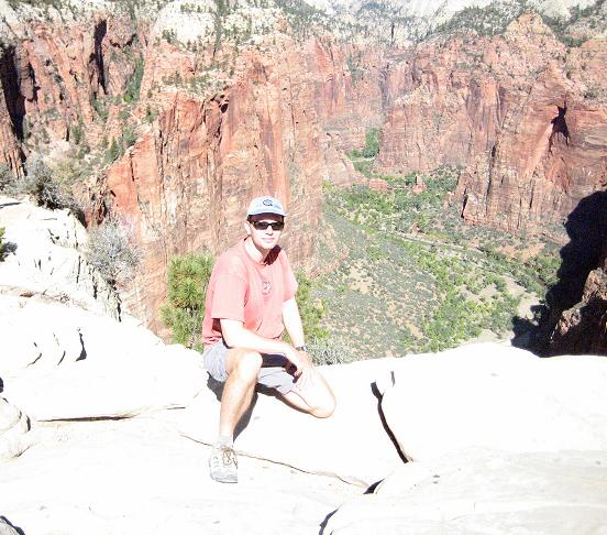
Regardless of the man made backdrop, the views of the canyon walls and the river are incredible.  We took the Riverside walk, and then climbed up to the Upper Emerald Pool.  We camped for 2 nights at the South Campground right next to the river.  The water in Zion gives it a much cooler feel, even when the temperature is high.  We also hiked the the Angel’s Landing trail.  I made it as far as the Scout Lookout and then backed out when I reached the steep cliffs and chains.  Eric (aka The Mountain Goat) had no problem with the thousand foot sheer drops on either side of the narrow knife edge trail.  He made it to the end and was rewarded with fantastic views of the whole canyon.  Here he is at the summit: 

utahoct08-blog4.jpg

Greetings from (the) Tropic

Friday, October 17th, 2008

…Tropic, Utah, that is, which didn’t quite live up to the name. We arrived outside of Bryce Canyon to record low temperatures of 14 deg F. Not quite “tropical,“ so our decision on whether to camp was pretty easy. We opted for some cute, warm cabins the first night instead.

After 2 days, we had stayed at half the hotels (2 of 4) and eaten at all the (i.e. both) restaurants in town. However, it’s close to the NP and a pretty good value. Bryce Canyon itself is amazing and best explored on foot. We hiked the Navajo Loop/Queen’s Garden trail one day, and the Peekaboo Loop from Bryce Point the next. Here’s just one of about two hundred pictures we took of the Hoodoos. 

utahoct08-blog3.JPG

120 Hours of Moab

Sunday, October 12th, 2008

No, we didn’t participate in a longer version of the 24 Hours of Moab bike race (it’s for crazy people – check it out), but we did get to experience quite a bit in our time here. 

Utah continues to provide incredible scenery. We spent another few days in the Arches and Canyonlands NPs, and took a ranger-guided hike into a place called the Fiery Furnace, full of slots to squeeze through and rocks to climb over.  We also took another walk up to the Landscape Arch which is over 300 feet long, Partition Arch, and the remains of Wall Arch which collapsed earlier this year. I can’t imagine what it must have been like to see that 10,000-year event.

We also got lucky and scored a campsite in the Devil’s Garden, which normally has people waiting in line at 8AM.  However, it was a restless night with wind gusts up to 30 mph.  The tent held up, but maybe everyone else knew something we didn’t.

Since we spent a few nights there, Moab is definitely worth a few words. It’s a pretty interesting place with some of the vibe of a ski resort town. It’s filled with a strange variety of people drawn here by the natural resources – everything from cowboy off-road vehicle enthusiasts to nouveau hippie rock climbers, with retired RVers, and tons of German tourists mixed in. I’ve never seen so many Jeeps in one place. We suspect there may be a law against pickups with less than 8 cylinders and 5 liter engines, because there don‘t seem to be any.

All kidding aside, we really enjoyed our time here. I think Moab may have some of  the most creative T-shirt designers in the world. I’ll leave you with the caption from one with a picture of some hikers: “Bring a compass – It’s awkward if you have to eat your friends.”

Here’s a parting shot of Skull Rock from inside the Fiery Furnace. Next stop, Bryce.

utahoct08-blog2.JPG

Utahhhhh!

Thursday, October 9th, 2008

After a recovery from Vegas, we made it to Utah.   The drive to Moab is incredible and reminds you just how big and empty this country is. 

We first headed to Arches National Park and did an few short hikes.  You don’t have to walk far in this place to see some fantastic views and rock formations like no where else.  Next we drove down to Canyonlands National Park and did some more hiking in the Needles area.  The scenery there was totally different from Arches, but just as beautiful in it’s own way.  Today we came back up to Moab and hiked out to the Morning Glory natural bridge, yet another amazing formation.

After 3 days of hiking and 2 nights of camping, we opted for a motel room tonight.  Ahhh!  A shower and bed felt like luxury.   Here we are at the top of the Delicate Arch hike:

utahoct08-blog.JPG

Miles Driven: 1020 (for more trip info, check out the new Scoreboard at right)